|
|
|||||||||||||||||
| Point ID: 6291 | Downloads | Plots | Site Data | Code: 3405 |
|
|
|||||||||||||||||
| Download | |
|---|---|
| Site Descriptor Information | Site Time Series Data |
| Link to all available data | |
| View: | Time Series | All |
| Units: | mm |
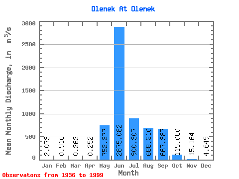
| Statistic | Jan | Feb | Mar | Apr | May | Jun | Jul | Aug | Sep | Oct | Nov | Dec | Annual |
|---|---|---|---|---|---|---|---|---|---|---|---|---|---|
| Mean | 2.07 | 0.92 | 0.26 | 0.25 | 752.38 | 2875.08 | 900.31 | 688.31 | 667.39 | 115.08 | 15.16 | 4.65 | 496.12 |
| Standard Deviation | 4.97 | 2.85 | 0.34 | 0.37 | 821.77 | 1160.43 | 637.12 | 536.53 | 421.62 | 78.12 | 14.85 | 7.27 | 131.86 |
| Min | 0.00 | 0.00 | 0.00 | 0.00 | 0.16 | 870.00 | 54.80 | 42.30 | 38.60 | 12.70 | 2.33 | 0.00 | 204.19 |
| Max | 36.10 | 21.70 | 1.24 | 1.55 | 3720.00 | 5640.00 | 3600.00 | 2380.00 | 2240.00 | 441.00 | 97.60 | 42.40 | 822.77 |
| Coefficient of Variation | 2.40 | 3.12 | 1.31 | 1.48 | 1.09 | 0.40 | 0.71 | 0.78 | 0.63 | 0.68 | 0.98 | 1.56 | 0.27 |
 Return to R-Arctic Net Home Page