|
|
|||||||||||||||||
| Point ID: 6291 | Downloads | Plots | Site Data | Code: 3405 |
|
|
|||||||||||||||||
| Download | |
|---|---|
| Site Descriptor Information | Site Time Series Data |
| Link to all available data | |
| View: | Time Series | All |
| Units: | m3/s |
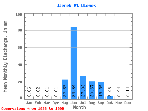
| Statistic | Jan | Feb | Mar | Apr | May | Jun | Jul | Aug | Sep | Oct | Nov | Dec | Annual |
|---|---|---|---|---|---|---|---|---|---|---|---|---|---|
| Mean | 0.06 | 0.03 | 0.01 | 0.01 | 22.59 | 83.55 | 27.03 | 20.66 | 19.39 | 3.46 | 0.44 | 0.14 | 175.53 |
| Standard Deviation | 0.15 | 0.08 | 0.01 | 0.01 | 24.67 | 33.72 | 19.13 | 16.11 | 12.25 | 2.34 | 0.43 | 0.22 | 46.66 |
| Min | 0.00 | 0.00 | 0.00 | 0.00 | 0.01 | 25.28 | 1.65 | 1.27 | 1.12 | 0.38 | 0.07 | 0.00 | 72.25 |
| Max | 1.08 | 0.59 | 0.04 | 0.04 | 111.68 | 163.89 | 108.08 | 71.45 | 65.09 | 13.24 | 2.84 | 1.27 | 291.11 |
| Coefficient of Variation | 2.40 | 3.12 | 1.31 | 1.48 | 1.09 | 0.40 | 0.71 | 0.78 | 0.63 | 0.68 | 0.98 | 1.56 | 0.27 |
 Return to R-Arctic Net Home Page