|
|
|||||||||||||||||
| Point ID: 6281 | Downloads | Plots | Site Data | Code: 3373 |
|
|
|||||||||||||||||
| Download | |
|---|---|
| Site Descriptor Information | Site Time Series Data |
| Link to all available data | |
| View: | Time Series | All |
| Units: | mm |
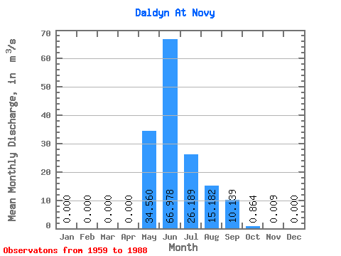
| Statistic | Jan | Feb | Mar | Apr | May | Jun | Jul | Aug | Sep | Oct | Nov | Dec | Annual |
|---|---|---|---|---|---|---|---|---|---|---|---|---|---|
| Mean | 0.00 | 0.00 | 0.00 | 0.00 | 34.56 | 66.98 | 26.19 | 15.18 | 10.14 | 0.86 | 0.01 | 0.00 | 12.83 |
| Standard Deviation | 0.00 | 0.00 | 0.00 | 0.00 | 24.41 | 32.05 | 29.77 | 18.18 | 7.79 | 0.85 | 0.02 | 0.00 | 4.28 |
| Min | 0.00 | 0.00 | 0.00 | 0.00 | 0.59 | 21.20 | 0.42 | 0.21 | 0.25 | 0.05 | 0.00 | 0.00 | 6.25 |
| Max | 0.00 | 0.00 | 0.00 | 0.00 | 75.40 | 121.00 | 115.00 | 64.80 | 27.10 | 3.39 | 0.05 | 0.00 | 19.65 |
| Coefficient of Variation | 0.71 | 0.48 | 1.14 | 1.20 | 0.77 | 0.99 | 1.79 | 0.33 |
 Return to R-Arctic Net Home Page