|
|
|||||||||||||||||
| Point ID: 6281 | Downloads | Plots | Site Data | Code: 3373 |
|
|
|||||||||||||||||
| Download | |
|---|---|
| Site Descriptor Information | Site Time Series Data |
| Link to all available data | |
| View: | Time Series | All |
| Units: | m3/s |
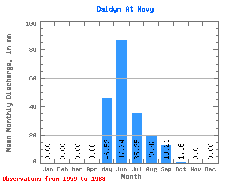
| Statistic | Jan | Feb | Mar | Apr | May | Jun | Jul | Aug | Sep | Oct | Nov | Dec | Annual |
|---|---|---|---|---|---|---|---|---|---|---|---|---|---|
| Mean | 0.00 | 0.00 | 0.00 | 0.00 | 46.51 | 87.24 | 35.24 | 20.43 | 13.21 | 1.16 | 0.01 | 0.00 | 203.42 |
| Standard Deviation | 0.00 | 0.00 | 0.00 | 0.00 | 32.85 | 41.75 | 40.06 | 24.46 | 10.14 | 1.15 | 0.02 | 0.00 | 67.90 |
| Min | 0.00 | 0.00 | 0.00 | 0.00 | 0.79 | 27.61 | 0.56 | 0.28 | 0.33 | 0.07 | 0.00 | 0.00 | 99.18 |
| Max | 0.00 | 0.00 | 0.00 | 0.00 | 101.47 | 157.60 | 154.76 | 87.20 | 35.30 | 4.56 | 0.07 | 0.00 | 311.68 |
| Coefficient of Variation | 0.71 | 0.48 | 1.14 | 1.20 | 0.77 | 0.99 | 1.79 | 0.33 |
 Return to R-Arctic Net Home Page