|
|
|||||||||||||||||
| Point ID: 6272 | Downloads | Plots | Site Data | Code: 3343 |
|
|
|||||||||||||||||
| Download | |
|---|---|
| Site Descriptor Information | Site Time Series Data |
| Link to all available data | |
| View: | Time Series | All |
| Units: | mm |
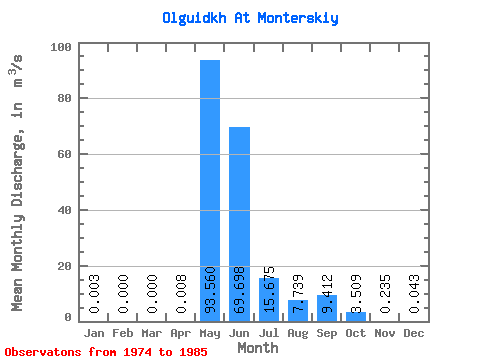
| Statistic | Jan | Feb | Mar | Apr | May | Jun | Jul | Aug | Sep | Oct | Nov | Dec | Annual |
|---|---|---|---|---|---|---|---|---|---|---|---|---|---|
| Mean | 0.00 | 0.00 | 0.00 | 0.01 | 93.56 | 69.70 | 15.68 | 7.74 | 9.41 | 3.51 | 0.23 | 0.04 | 15.64 |
| Standard Deviation | 0.01 | 0.00 | 0.00 | 0.01 | 38.05 | 41.37 | 26.17 | 13.09 | 14.25 | 6.13 | 0.34 | 0.08 | 5.36 |
| Min | 0.00 | 0.00 | 0.00 | 0.00 | 40.80 | 4.98 | 1.24 | 0.41 | 0.33 | 0.10 | 0.03 | 0.00 | 4.14 |
| Max | 0.02 | 0.00 | 0.00 | 0.04 | 146.00 | 137.00 | 91.40 | 38.20 | 41.80 | 21.50 | 1.30 | 0.30 | 22.12 |
| Coefficient of Variation | 1.69 | 1.91 | 0.41 | 0.59 | 1.67 | 1.69 | 1.51 | 1.75 | 1.46 | 1.90 | 0.34 |
 Return to R-Arctic Net Home Page