|
|
|||||||||||||||||
| Point ID: 6272 | Downloads | Plots | Site Data | Code: 3343 |
|
|
|||||||||||||||||
| Download | |
|---|---|
| Site Descriptor Information | Site Time Series Data |
| Link to all available data | |
| View: | Time Series | All |
| Units: | m3/s |
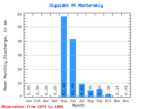
| Statistic | Jan | Feb | Mar | Apr | May | Jun | Jul | Aug | Sep | Oct | Nov | Dec | Annual |
|---|---|---|---|---|---|---|---|---|---|---|---|---|---|
| Mean | 0.00 | 0.00 | 0.00 | 0.01 | 57.47 | 41.44 | 9.63 | 4.75 | 5.59 | 2.15 | 0.14 | 0.03 | 113.21 |
| Standard Deviation | 0.00 | 0.00 | 0.00 | 0.01 | 23.37 | 24.60 | 16.08 | 8.04 | 8.47 | 3.77 | 0.20 | 0.05 | 38.80 |
| Min | 0.00 | 0.00 | 0.00 | 0.00 | 25.06 | 2.96 | 0.76 | 0.25 | 0.20 | 0.06 | 0.02 | 0.00 | 29.94 |
| Max | 0.01 | 0.00 | 0.00 | 0.03 | 89.68 | 81.45 | 56.14 | 23.46 | 24.85 | 13.21 | 0.77 | 0.18 | 160.10 |
| Coefficient of Variation | 1.69 | 1.91 | 0.41 | 0.59 | 1.67 | 1.69 | 1.51 | 1.75 | 1.46 | 1.90 | 0.34 |
 Return to R-Arctic Net Home Page