|
|
|||||||||||||||||
| Point ID: 627 | Downloads | Plots | Site Data | Code: 07AF907 |
|
|
|||||||||||||||||
| Download | |
|---|---|
| Site Descriptor Information | Site Time Series Data |
| Link to all available data | |
| View: | Time Series | All |
| Units: | mm |
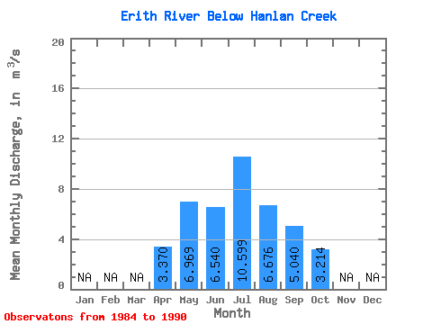
| Statistic | Jan | Feb | Mar | Apr | May | Jun | Jul | Aug | Sep | Oct | Nov | Dec | Annual |
|---|---|---|---|---|---|---|---|---|---|---|---|---|---|
| Mean | 3.37 | 6.97 | 6.54 | 10.60 | 6.68 | 5.04 | 3.21 | ||||||
| Standard Deviation | 5.15 | 5.72 | 15.19 | 6.94 | 3.21 | 2.33 | |||||||
| Min | 3.37 | 2.27 | 1.71 | 0.96 | 0.71 | 1.27 | 1.01 | ||||||
| Max | 3.37 | 16.30 | 19.10 | 39.30 | 20.10 | 9.11 | 7.88 | ||||||
| Coefficient of Variation | 0.74 | 0.87 | 1.43 | 1.04 | 0.64 | 0.73 |
 Return to R-Arctic Net Home Page