|
|
|||||||||||||||||
| Point ID: 627 | Downloads | Plots | Site Data | Code: 07AF907 |
|
|
|||||||||||||||||
| Download | |
|---|---|
| Site Descriptor Information | Site Time Series Data |
| Link to all available data | |
| View: | Time Series | All |
| Units: | m3/s |
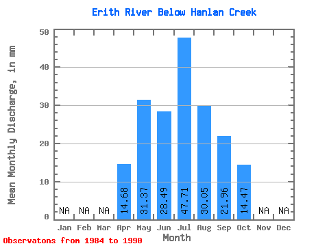
| Statistic | Jan | Feb | Mar | Apr | May | Jun | Jul | Aug | Sep | Oct | Nov | Dec | Annual |
|---|---|---|---|---|---|---|---|---|---|---|---|---|---|
| Mean | 14.68 | 31.36 | 28.49 | 47.70 | 30.05 | 21.96 | 14.47 | ||||||
| Standard Deviation | 23.19 | 24.91 | 68.38 | 31.24 | 13.97 | 10.50 | |||||||
| Min | 14.68 | 10.22 | 7.45 | 4.33 | 3.21 | 5.53 | 4.55 | ||||||
| Max | 14.68 | 73.36 | 83.20 | 176.88 | 90.47 | 39.69 | 35.47 | ||||||
| Coefficient of Variation | 0.74 | 0.87 | 1.43 | 1.04 | 0.64 | 0.73 |
 Return to R-Arctic Net Home Page