|
|
|||||||||||||||||
| Point ID: 6259 | Downloads | Plots | Site Data | Code: 3303 |
|
|
|||||||||||||||||
| Download | |
|---|---|
| Site Descriptor Information | Site Time Series Data |
| Link to all available data | |
| View: | Time Series | All |
| Units: | mm |
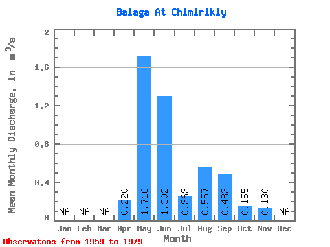
| Statistic | Jan | Feb | Mar | Apr | May | Jun | Jul | Aug | Sep | Oct | Nov | Dec | Annual |
|---|---|---|---|---|---|---|---|---|---|---|---|---|---|
| Mean | 0.22 | 1.72 | 1.30 | 0.26 | 0.56 | 0.48 | 0.15 | 0.13 | |||||
| Standard Deviation | 2.14 | 1.67 | 0.43 | 1.51 | 1.33 | 0.28 | |||||||
| Min | 0.22 | 0.02 | 0.00 | 0.00 | 0.00 | 0.00 | 0.00 | 0.13 | |||||
| Max | 0.22 | 6.74 | 5.32 | 1.82 | 6.06 | 5.56 | 0.99 | 0.13 | |||||
| Coefficient of Variation | 1.25 | 1.28 | 1.65 | 2.72 | 2.76 | 1.83 |
 Return to R-Arctic Net Home Page