|
|
|||||||||||||||||
| Point ID: 6259 | Downloads | Plots | Site Data | Code: 3303 |
|
|
|||||||||||||||||
| Download | |
|---|---|
| Site Descriptor Information | Site Time Series Data |
| Link to all available data | |
| View: | Time Series | All |
| Units: | m3/s |
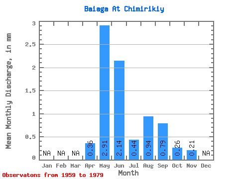
| Statistic | Jan | Feb | Mar | Apr | May | Jun | Jul | Aug | Sep | Oct | Nov | Dec | Annual |
|---|---|---|---|---|---|---|---|---|---|---|---|---|---|
| Mean | 0.36 | 2.91 | 2.14 | 0.44 | 0.94 | 0.79 | 0.26 | 0.21 | |||||
| Standard Deviation | 3.62 | 2.74 | 0.73 | 2.56 | 2.18 | 0.48 | |||||||
| Min | 0.36 | 0.03 | 0.01 | 0.00 | 0.00 | 0.00 | 0.00 | 0.21 | |||||
| Max | 0.36 | 11.42 | 8.73 | 3.08 | 10.27 | 9.12 | 1.68 | 0.21 | |||||
| Coefficient of Variation | 1.25 | 1.28 | 1.65 | 2.72 | 2.76 | 1.83 |
 Return to R-Arctic Net Home Page