|
|
|||||||||||||||||
| Point ID: 624 | Downloads | Plots | Site Data | Code: 07AF015 |
|
|
|||||||||||||||||
| Download | |
|---|---|
| Site Descriptor Information | Site Time Series Data |
| Link to all available data | |
| View: | Time Series | All |
| Units: | mm |
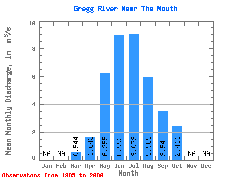
| Statistic | Jan | Feb | Mar | Apr | May | Jun | Jul | Aug | Sep | Oct | Nov | Dec | Annual |
|---|---|---|---|---|---|---|---|---|---|---|---|---|---|
| Mean | 0.54 | 1.64 | 6.25 | 8.99 | 9.07 | 5.99 | 3.54 | 2.41 | |||||
| Standard Deviation | 0.19 | 0.70 | 3.43 | 4.71 | 6.09 | 4.64 | 2.00 | 1.38 | |||||
| Min | 0.26 | 0.84 | 1.88 | 1.78 | 2.03 | 1.13 | 1.22 | 1.09 | |||||
| Max | 0.85 | 3.14 | 16.30 | 20.30 | 23.90 | 15.60 | 7.72 | 6.52 | |||||
| Coefficient of Variation | 0.34 | 0.42 | 0.55 | 0.52 | 0.67 | 0.78 | 0.56 | 0.57 |
 Return to R-Arctic Net Home Page