|
|
|||||||||||||||||
| Point ID: 624 | Downloads | Plots | Site Data | Code: 07AF015 |
|
|
|||||||||||||||||
| Download | |
|---|---|
| Site Descriptor Information | Site Time Series Data |
| Link to all available data | |
| View: | Time Series | All |
| Units: | m3/s |
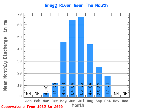
| Statistic | Jan | Feb | Mar | Apr | May | Jun | Jul | Aug | Sep | Oct | Nov | Dec | Annual |
|---|---|---|---|---|---|---|---|---|---|---|---|---|---|
| Mean | 4.00 | 11.70 | 46.02 | 64.04 | 66.75 | 44.03 | 25.21 | 17.73 | |||||
| Standard Deviation | 1.37 | 4.96 | 25.21 | 33.54 | 44.77 | 34.11 | 14.23 | 10.18 | |||||
| Min | 1.91 | 6.01 | 13.83 | 12.68 | 14.94 | 8.31 | 8.69 | 8.02 | |||||
| Max | 6.22 | 22.36 | 119.92 | 144.55 | 175.84 | 114.77 | 54.97 | 47.97 | |||||
| Coefficient of Variation | 0.34 | 0.42 | 0.55 | 0.52 | 0.67 | 0.78 | 0.56 | 0.57 |
 Return to R-Arctic Net Home Page