|
|
|||||||||||||||||
| Point ID: 6227 | Downloads | Plots | Site Data | Code: 3208 |
|
|
|||||||||||||||||
| Download | |
|---|---|
| Site Descriptor Information | Site Time Series Data |
| Link to all available data | |
| View: | Time Series | All |
| Units: | mm |
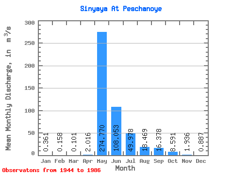
| Statistic | Jan | Feb | Mar | Apr | May | Jun | Jul | Aug | Sep | Oct | Nov | Dec | Annual |
|---|---|---|---|---|---|---|---|---|---|---|---|---|---|
| Mean | 0.36 | 0.16 | 0.10 | 2.02 | 274.77 | 108.05 | 49.98 | 18.47 | 16.38 | 8.59 | 1.94 | 0.89 | 42.04 |
| Standard Deviation | 0.32 | 0.21 | 0.20 | 5.06 | 165.05 | 82.93 | 78.78 | 30.52 | 22.16 | 8.52 | 1.69 | 0.51 | 22.83 |
| Min | 0.00 | 0.00 | 0.00 | 0.00 | 15.70 | 13.10 | 4.29 | 1.41 | 1.88 | 0.89 | 0.43 | 0.16 | 8.39 |
| Max | 1.12 | 0.81 | 0.62 | 29.20 | 781.00 | 370.00 | 381.00 | 171.00 | 117.00 | 43.00 | 10.90 | 2.84 | 99.47 |
| Coefficient of Variation | 0.87 | 1.33 | 1.97 | 2.51 | 0.60 | 0.77 | 1.58 | 1.65 | 1.35 | 0.99 | 0.87 | 0.57 | 0.54 |
 Return to R-Arctic Net Home Page