|
|
|||||||||||||||||
| Point ID: 6227 | Downloads | Plots | Site Data | Code: 3208 |
|
|
|||||||||||||||||
| Download | |
|---|---|
| Site Descriptor Information | Site Time Series Data |
| Link to all available data | |
| View: | Time Series | All |
| Units: | m3/s |
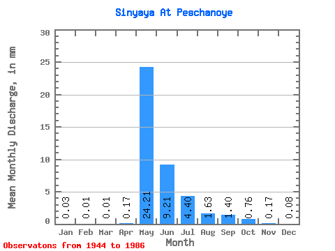
| Statistic | Jan | Feb | Mar | Apr | May | Jun | Jul | Aug | Sep | Oct | Nov | Dec | Annual |
|---|---|---|---|---|---|---|---|---|---|---|---|---|---|
| Mean | 0.03 | 0.01 | 0.01 | 0.17 | 24.20 | 9.21 | 4.40 | 1.63 | 1.40 | 0.76 | 0.17 | 0.08 | 43.65 |
| Standard Deviation | 0.03 | 0.02 | 0.02 | 0.43 | 14.54 | 7.07 | 6.94 | 2.69 | 1.89 | 0.75 | 0.14 | 0.04 | 23.70 |
| Min | 0.00 | 0.00 | 0.00 | 0.00 | 1.38 | 1.12 | 0.38 | 0.12 | 0.16 | 0.08 | 0.04 | 0.01 | 8.71 |
| Max | 0.10 | 0.07 | 0.06 | 2.49 | 68.80 | 31.55 | 33.56 | 15.06 | 9.98 | 3.79 | 0.93 | 0.25 | 103.27 |
| Coefficient of Variation | 0.87 | 1.33 | 1.97 | 2.51 | 0.60 | 0.77 | 1.58 | 1.65 | 1.35 | 0.99 | 0.87 | 0.57 | 0.54 |
 Return to R-Arctic Net Home Page