|
|
|||||||||||||||||
| Point ID: 6220 | Downloads | Plots | Site Data | Code: 3178 |
|
|
|||||||||||||||||
| Download | |
|---|---|
| Site Descriptor Information | Site Time Series Data |
| Link to all available data | |
| View: | Time Series | All |
| Units: | mm |
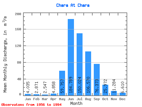
| Statistic | Jan | Feb | Mar | Apr | May | Jun | Jul | Aug | Sep | Oct | Nov | Dec | Annual |
|---|---|---|---|---|---|---|---|---|---|---|---|---|---|
| Mean | 4.04 | 2.87 | 2.55 | 4.86 | 59.76 | 184.79 | 150.02 | 106.57 | 76.37 | 25.97 | 11.28 | 6.61 | 52.97 |
| Standard Deviation | 1.36 | 1.27 | 1.47 | 3.55 | 23.50 | 50.63 | 59.94 | 60.59 | 34.45 | 7.93 | 2.64 | 1.62 | 12.00 |
| Min | 0.56 | 0.00 | 0.00 | 0.49 | 23.30 | 87.00 | 41.90 | 19.10 | 30.40 | 9.18 | 7.31 | 3.29 | 26.95 |
| Max | 6.34 | 5.75 | 6.89 | 15.60 | 111.00 | 264.00 | 304.00 | 374.00 | 182.00 | 51.40 | 17.60 | 10.90 | 90.19 |
| Coefficient of Variation | 0.34 | 0.44 | 0.58 | 0.73 | 0.39 | 0.27 | 0.40 | 0.57 | 0.45 | 0.30 | 0.23 | 0.25 | 0.23 |
 Return to R-Arctic Net Home Page