|
|
|||||||||||||||||
| Point ID: 6220 | Downloads | Plots | Site Data | Code: 3178 |
|
|
|||||||||||||||||
| Download | |
|---|---|
| Site Descriptor Information | Site Time Series Data |
| Link to all available data | |
| View: | Time Series | All |
| Units: | m3/s |
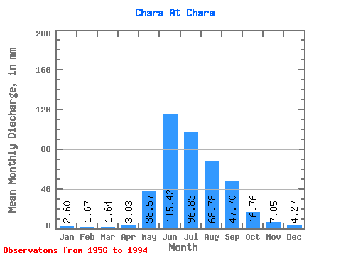
| Statistic | Jan | Feb | Mar | Apr | May | Jun | Jul | Aug | Sep | Oct | Nov | Dec | Annual |
|---|---|---|---|---|---|---|---|---|---|---|---|---|---|
| Mean | 2.60 | 1.69 | 1.64 | 3.03 | 38.56 | 115.42 | 96.81 | 68.77 | 47.70 | 16.76 | 7.05 | 4.26 | 402.80 |
| Standard Deviation | 0.88 | 0.75 | 0.95 | 2.22 | 15.16 | 31.62 | 38.68 | 39.10 | 21.51 | 5.12 | 1.65 | 1.05 | 91.25 |
| Min | 0.36 | 0.00 | 0.00 | 0.31 | 15.04 | 54.34 | 27.04 | 12.32 | 18.99 | 5.92 | 4.57 | 2.12 | 204.98 |
| Max | 4.09 | 3.38 | 4.45 | 9.74 | 71.63 | 164.89 | 196.17 | 241.34 | 113.67 | 33.17 | 10.99 | 7.03 | 685.84 |
| Coefficient of Variation | 0.34 | 0.44 | 0.58 | 0.73 | 0.39 | 0.27 | 0.40 | 0.57 | 0.45 | 0.30 | 0.23 | 0.25 | 0.23 |
 Return to R-Arctic Net Home Page