|
|
|||||||||||||||||
| Point ID: 6213 | Downloads | Plots | Site Data | Code: 3160 |
|
|
|||||||||||||||||
| Download | |
|---|---|
| Site Descriptor Information | Site Time Series Data |
| Link to all available data | |
| View: | Time Series | All |
| Units: | mm |
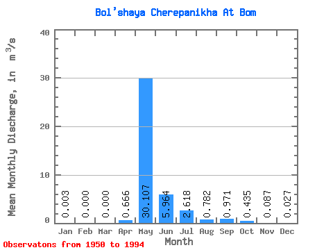
| Statistic | Jan | Feb | Mar | Apr | May | Jun | Jul | Aug | Sep | Oct | Nov | Dec | Annual |
|---|---|---|---|---|---|---|---|---|---|---|---|---|---|
| Mean | 0.00 | 0.00 | 0.00 | 0.67 | 30.11 | 5.96 | 2.62 | 0.78 | 0.97 | 0.43 | 0.09 | 0.03 | 3.50 |
| Standard Deviation | 0.01 | 0.00 | 0.00 | 1.67 | 18.45 | 4.80 | 6.72 | 1.57 | 1.27 | 0.40 | 0.10 | 0.07 | 2.13 |
| Min | 0.00 | 0.00 | 0.00 | 0.00 | 0.00 | 0.80 | 0.11 | 0.10 | 0.12 | 0.08 | 0.00 | 0.00 | 0.44 |
| Max | 0.03 | 0.00 | 0.00 | 9.76 | 80.50 | 21.50 | 43.60 | 10.00 | 7.06 | 1.91 | 0.57 | 0.34 | 11.93 |
| Coefficient of Variation | 2.43 | 6.63 | 2.50 | 0.61 | 0.80 | 2.57 | 2.01 | 1.31 | 0.91 | 1.22 | 2.51 | 0.61 |
 Return to R-Arctic Net Home Page