|
|
|||||||||||||||||
| Point ID: 6213 | Downloads | Plots | Site Data | Code: 3160 |
|
|
|||||||||||||||||
| Download | |
|---|---|
| Site Descriptor Information | Site Time Series Data |
| Link to all available data | |
| View: | Time Series | All |
| Units: | m3/s |
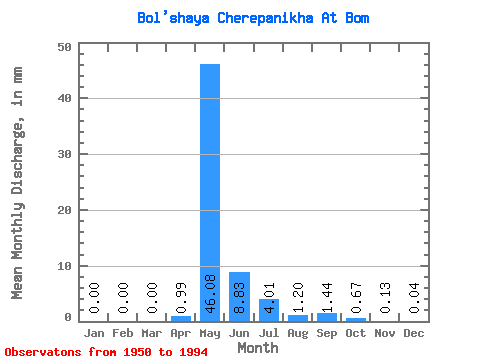
| Statistic | Jan | Feb | Mar | Apr | May | Jun | Jul | Aug | Sep | Oct | Nov | Dec | Annual |
|---|---|---|---|---|---|---|---|---|---|---|---|---|---|
| Mean | 0.00 | 0.00 | 0.00 | 0.99 | 46.07 | 8.83 | 4.01 | 1.20 | 1.44 | 0.67 | 0.13 | 0.04 | 63.17 |
| Standard Deviation | 0.01 | 0.00 | 0.00 | 2.47 | 28.24 | 7.10 | 10.28 | 2.41 | 1.88 | 0.61 | 0.16 | 0.10 | 38.38 |
| Min | 0.00 | 0.00 | 0.00 | 0.00 | 0.00 | 1.19 | 0.17 | 0.15 | 0.18 | 0.12 | 0.00 | 0.00 | 8.01 |
| Max | 0.05 | 0.00 | 0.00 | 14.46 | 123.19 | 31.84 | 66.72 | 15.30 | 10.46 | 2.92 | 0.84 | 0.52 | 215.15 |
| Coefficient of Variation | 2.43 | 6.63 | 2.50 | 0.61 | 0.80 | 2.57 | 2.01 | 1.31 | 0.91 | 1.22 | 2.51 | 0.61 |
 Return to R-Arctic Net Home Page