|
|
|||||||||||||||||
| Point ID: 6196 | Downloads | Plots | Site Data | Code: 3135 |
|
|
|||||||||||||||||
| Download | |
|---|---|
| Site Descriptor Information | Site Time Series Data |
| Link to all available data | |
| View: | Time Series | All |
| Units: | mm |
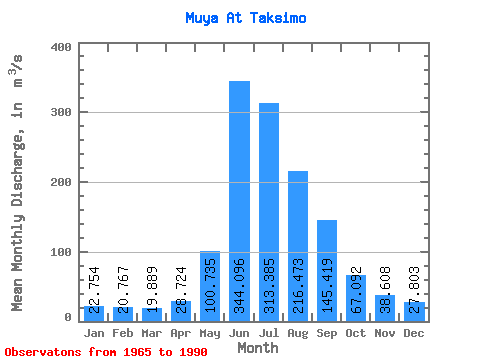
| Statistic | Jan | Feb | Mar | Apr | May | Jun | Jul | Aug | Sep | Oct | Nov | Dec | Annual |
|---|---|---|---|---|---|---|---|---|---|---|---|---|---|
| Mean | 22.75 | 20.77 | 19.89 | 28.72 | 100.73 | 344.10 | 313.38 | 216.47 | 145.42 | 67.09 | 38.61 | 27.80 | 112.64 |
| Standard Deviation | 6.83 | 7.62 | 6.65 | 8.23 | 58.22 | 119.45 | 163.97 | 77.87 | 48.49 | 16.87 | 10.68 | 6.71 | 28.36 |
| Min | 7.10 | 3.66 | 4.11 | 12.20 | 28.70 | 48.50 | 52.80 | 52.50 | 33.90 | 26.10 | 14.70 | 9.49 | 27.86 |
| Max | 37.90 | 40.00 | 37.00 | 46.30 | 309.00 | 552.00 | 626.00 | 359.00 | 246.00 | 99.60 | 62.70 | 37.00 | 160.03 |
| Coefficient of Variation | 0.30 | 0.37 | 0.33 | 0.29 | 0.58 | 0.35 | 0.52 | 0.36 | 0.33 | 0.25 | 0.28 | 0.24 | 0.25 |
 Return to R-Arctic Net Home Page