|
|
|||||||||||||||||
| Point ID: 6196 | Downloads | Plots | Site Data | Code: 3135 |
|
|
|||||||||||||||||
| Download | |
|---|---|
| Site Descriptor Information | Site Time Series Data |
| Link to all available data | |
| View: | Time Series | All |
| Units: | m3/s |
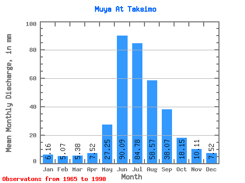
| Statistic | Jan | Feb | Mar | Apr | May | Jun | Jul | Aug | Sep | Oct | Nov | Dec | Annual |
|---|---|---|---|---|---|---|---|---|---|---|---|---|---|
| Mean | 6.16 | 5.12 | 5.38 | 7.52 | 27.25 | 90.09 | 84.77 | 58.56 | 38.07 | 18.15 | 10.11 | 7.52 | 359.08 |
| Standard Deviation | 1.85 | 1.88 | 1.80 | 2.16 | 15.75 | 31.27 | 44.35 | 21.07 | 12.70 | 4.56 | 2.79 | 1.81 | 90.40 |
| Min | 1.92 | 0.90 | 1.11 | 3.19 | 7.76 | 12.70 | 14.28 | 14.20 | 8.88 | 7.06 | 3.85 | 2.57 | 88.83 |
| Max | 10.25 | 9.86 | 10.01 | 12.12 | 83.59 | 144.52 | 169.34 | 97.11 | 64.41 | 26.94 | 16.42 | 10.01 | 510.14 |
| Coefficient of Variation | 0.30 | 0.37 | 0.33 | 0.29 | 0.58 | 0.35 | 0.52 | 0.36 | 0.33 | 0.25 | 0.28 | 0.24 | 0.25 |
 Return to R-Arctic Net Home Page