|
|
|||||||||||||||||
| Point ID: 6193 | Downloads | Plots | Site Data | Code: 3132 |
|
|
|||||||||||||||||
| Download | |
|---|---|
| Site Descriptor Information | Site Time Series Data |
| Link to all available data | |
| View: | Time Series | All |
| Units: | mm |
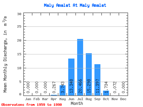
| Statistic | Jan | Feb | Mar | Apr | May | Jun | Jul | Aug | Sep | Oct | Nov | Dec | Annual |
|---|---|---|---|---|---|---|---|---|---|---|---|---|---|
| Mean | 0.00 | 0.00 | 0.00 | 0.27 | 3.74 | 13.35 | 20.47 | 15.30 | 11.40 | 1.73 | 0.07 | 0.00 | 5.53 |
| Standard Deviation | 0.00 | 0.00 | 0.00 | 0.36 | 3.92 | 15.27 | 22.39 | 13.09 | 11.62 | 1.17 | 0.07 | 0.00 | 3.39 |
| Min | 0.00 | 0.00 | 0.00 | 0.00 | 0.33 | 0.67 | 1.21 | 1.78 | 0.49 | 0.22 | 0.00 | 0.00 | 1.07 |
| Max | 0.00 | 0.00 | 0.00 | 1.35 | 14.60 | 72.30 | 94.20 | 40.50 | 47.80 | 4.60 | 0.29 | 0.00 | 12.14 |
| Coefficient of Variation | 1.35 | 1.05 | 1.14 | 1.09 | 0.86 | 1.02 | 0.67 | 0.95 | 0.61 |
 Return to R-Arctic Net Home Page