|
|
|||||||||||||||||
| Point ID: 6193 | Downloads | Plots | Site Data | Code: 3132 |
|
|
|||||||||||||||||
| Download | |
|---|---|
| Site Descriptor Information | Site Time Series Data |
| Link to all available data | |
| View: | Time Series | All |
| Units: | m3/s |
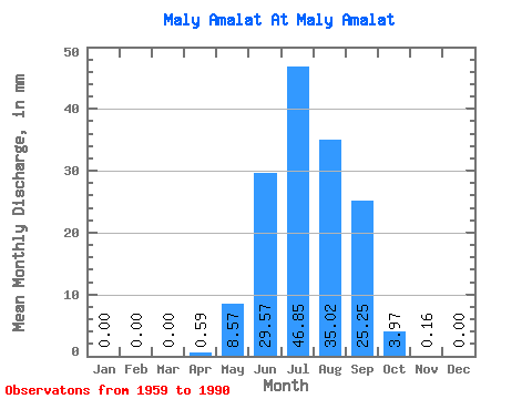
| Statistic | Jan | Feb | Mar | Apr | May | Jun | Jul | Aug | Sep | Oct | Nov | Dec | Annual |
|---|---|---|---|---|---|---|---|---|---|---|---|---|---|
| Mean | 0.00 | 0.00 | 0.00 | 0.59 | 8.57 | 29.57 | 46.84 | 35.02 | 25.25 | 3.97 | 0.16 | 0.00 | 149.09 |
| Standard Deviation | 0.00 | 0.00 | 0.00 | 0.80 | 8.98 | 33.84 | 51.24 | 29.97 | 25.75 | 2.68 | 0.15 | 0.00 | 91.39 |
| Min | 0.00 | 0.00 | 0.00 | 0.00 | 0.76 | 1.48 | 2.77 | 4.07 | 1.09 | 0.50 | 0.00 | 0.00 | 28.90 |
| Max | 0.00 | 0.00 | 0.00 | 2.99 | 33.42 | 160.17 | 215.61 | 92.70 | 105.89 | 10.53 | 0.64 | 0.00 | 327.51 |
| Coefficient of Variation | 1.35 | 1.05 | 1.14 | 1.09 | 0.86 | 1.02 | 0.67 | 0.95 | 0.61 |
 Return to R-Arctic Net Home Page