|
|
|||||||||||||||||
| Point ID: 6192 | Downloads | Plots | Site Data | Code: 3131 |
|
|
|||||||||||||||||
| Download | |
|---|---|
| Site Descriptor Information | Site Time Series Data |
| Link to all available data | |
| View: | Time Series | All |
| Units: | mm |
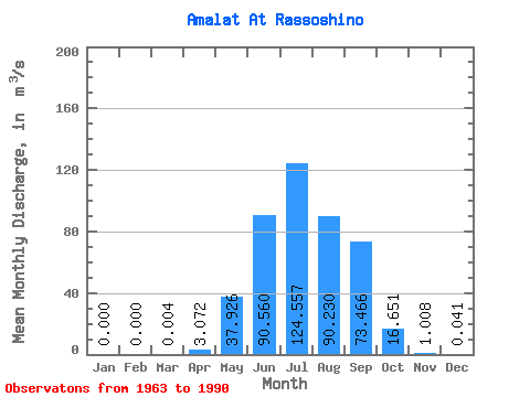
| Statistic | Jan | Feb | Mar | Apr | May | Jun | Jul | Aug | Sep | Oct | Nov | Dec | Annual |
|---|---|---|---|---|---|---|---|---|---|---|---|---|---|
| Mean | 0.00 | 0.00 | 0.00 | 3.07 | 37.93 | 90.56 | 124.56 | 90.23 | 73.47 | 16.65 | 1.01 | 0.04 | 36.46 |
| Standard Deviation | 0.00 | 0.00 | 0.02 | 3.09 | 36.17 | 109.76 | 145.66 | 98.22 | 91.17 | 19.66 | 0.52 | 0.05 | 25.44 |
| Min | 0.00 | 0.00 | 0.00 | 0.00 | 5.74 | 8.75 | 6.56 | 5.48 | 2.50 | 1.40 | 0.14 | 0.00 | 6.61 |
| Max | 0.00 | 0.00 | 0.10 | 9.89 | 126.00 | 537.00 | 625.00 | 323.00 | 366.00 | 104.00 | 2.30 | 0.19 | 87.28 |
| Coefficient of Variation | 5.29 | 1.01 | 0.95 | 1.21 | 1.17 | 1.09 | 1.24 | 1.18 | 0.52 | 1.29 | 0.70 |
 Return to R-Arctic Net Home Page