|
|
|||||||||||||||||
| Point ID: 6192 | Downloads | Plots | Site Data | Code: 3131 |
|
|
|||||||||||||||||
| Download | |
|---|---|
| Site Descriptor Information | Site Time Series Data |
| Link to all available data | |
| View: | Time Series | All |
| Units: | m3/s |
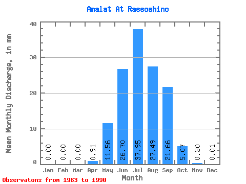
| Statistic | Jan | Feb | Mar | Apr | May | Jun | Jul | Aug | Sep | Oct | Nov | Dec | Annual |
|---|---|---|---|---|---|---|---|---|---|---|---|---|---|
| Mean | 0.00 | 0.00 | 0.00 | 0.91 | 11.55 | 26.70 | 37.95 | 27.49 | 21.66 | 5.07 | 0.30 | 0.01 | 130.91 |
| Standard Deviation | 0.00 | 0.00 | 0.01 | 0.91 | 11.02 | 32.37 | 44.38 | 29.92 | 26.88 | 5.99 | 0.15 | 0.02 | 91.33 |
| Min | 0.00 | 0.00 | 0.00 | 0.00 | 1.75 | 2.58 | 2.00 | 1.67 | 0.74 | 0.43 | 0.04 | 0.00 | 23.73 |
| Max | 0.00 | 0.00 | 0.03 | 2.92 | 38.39 | 158.35 | 190.41 | 98.41 | 107.93 | 31.68 | 0.68 | 0.06 | 313.37 |
| Coefficient of Variation | 5.29 | 1.01 | 0.95 | 1.21 | 1.17 | 1.09 | 1.24 | 1.18 | 0.52 | 1.29 | 0.70 |
 Return to R-Arctic Net Home Page