|
|
|||||||||||||||||
| Point ID: 6179 | Downloads | Plots | Site Data | Code: 3111 |
|
|
|||||||||||||||||
| Download | |
|---|---|
| Site Descriptor Information | Site Time Series Data |
| Link to all available data | |
| View: | Time Series | All |
| Units: | mm |
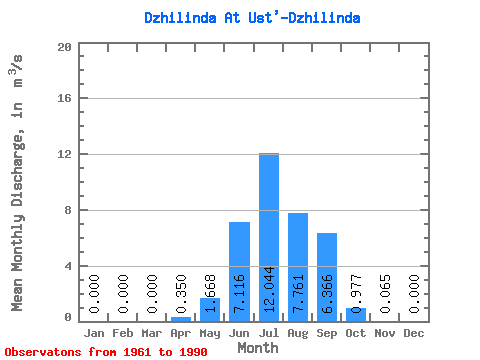
| Statistic | Jan | Feb | Mar | Apr | May | Jun | Jul | Aug | Sep | Oct | Nov | Dec | Annual |
|---|---|---|---|---|---|---|---|---|---|---|---|---|---|
| Mean | 0.00 | 0.00 | 0.00 | 0.35 | 1.67 | 7.12 | 12.04 | 7.76 | 6.37 | 0.98 | 0.07 | 0.00 | 3.08 |
| Standard Deviation | 0.00 | 0.00 | 0.00 | 0.82 | 2.48 | 10.06 | 15.24 | 9.90 | 10.66 | 0.94 | 0.07 | 0.00 | 2.56 |
| Min | 0.00 | 0.00 | 0.00 | 0.00 | 0.44 | 0.28 | 0.26 | 0.31 | 0.24 | 0.14 | 0.00 | 0.00 | 0.15 |
| Max | 0.00 | 0.00 | 0.00 | 4.27 | 13.50 | 39.80 | 58.30 | 33.10 | 48.40 | 3.32 | 0.33 | 0.01 | 9.44 |
| Coefficient of Variation | 2.34 | 1.49 | 1.41 | 1.27 | 1.27 | 1.68 | 0.97 | 1.15 | 3.50 | 0.83 |
 Return to R-Arctic Net Home Page