|
|
|||||||||||||||||
| Point ID: 6179 | Downloads | Plots | Site Data | Code: 3111 |
|
|
|||||||||||||||||
| Download | |
|---|---|
| Site Descriptor Information | Site Time Series Data |
| Link to all available data | |
| View: | Time Series | All |
| Units: | m3/s |
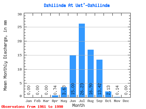
| Statistic | Jan | Feb | Mar | Apr | May | Jun | Jul | Aug | Sep | Oct | Nov | Dec | Annual |
|---|---|---|---|---|---|---|---|---|---|---|---|---|---|
| Mean | 0.00 | 0.00 | 0.00 | 0.74 | 3.63 | 14.99 | 26.22 | 16.90 | 13.41 | 2.13 | 0.14 | 0.00 | 79.14 |
| Standard Deviation | 0.00 | 0.00 | 0.00 | 1.72 | 5.41 | 21.20 | 33.17 | 21.55 | 22.47 | 2.06 | 0.16 | 0.00 | 65.79 |
| Min | 0.00 | 0.00 | 0.00 | 0.00 | 0.96 | 0.59 | 0.57 | 0.68 | 0.51 | 0.30 | 0.00 | 0.00 | 3.87 |
| Max | 0.00 | 0.00 | 0.00 | 9.00 | 29.39 | 83.87 | 126.93 | 72.07 | 101.99 | 7.23 | 0.69 | 0.02 | 242.19 |
| Coefficient of Variation | 2.34 | 1.49 | 1.41 | 1.27 | 1.27 | 1.68 | 0.97 | 1.15 | 3.50 | 0.83 |
 Return to R-Arctic Net Home Page