|
|
|||||||||||||||||
| Point ID: 6075 | Downloads | Plots | Site Data | Code: 7193 |
|
|
|||||||||||||||||
| Download | |
|---|---|
| Site Descriptor Information | Site Time Series Data |
| Link to all available data | |
| View: | Time Series | All |
| Units: | mm |
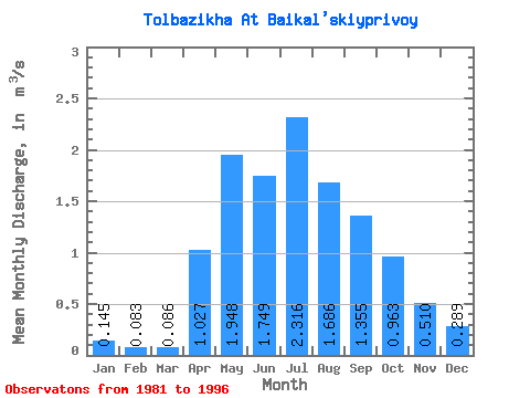
| Statistic | Jan | Feb | Mar | Apr | May | Jun | Jul | Aug | Sep | Oct | Nov | Dec | Annual |
|---|---|---|---|---|---|---|---|---|---|---|---|---|---|
| Mean | 0.14 | 0.08 | 0.09 | 1.03 | 1.95 | 1.75 | 2.32 | 1.69 | 1.35 | 0.96 | 0.51 | 0.29 | 1.04 |
| Standard Deviation | 0.08 | 0.05 | 0.05 | 0.50 | 0.80 | 1.71 | 1.88 | 1.27 | 0.81 | 0.50 | 0.23 | 0.18 | 0.42 |
| Min | 0.06 | 0.00 | 0.01 | 0.31 | 0.85 | 0.56 | 0.41 | 0.45 | 0.23 | 0.20 | 0.19 | 0.14 | 0.51 |
| Max | 0.31 | 0.16 | 0.19 | 1.83 | 3.85 | 7.51 | 5.60 | 3.95 | 2.86 | 1.95 | 0.98 | 0.83 | 1.71 |
| Coefficient of Variation | 0.56 | 0.57 | 0.62 | 0.49 | 0.41 | 0.98 | 0.81 | 0.76 | 0.60 | 0.52 | 0.44 | 0.62 | 0.40 |
 Return to R-Arctic Net Home Page