|
|
|||||||||||||||||
| Point ID: 6075 | Downloads | Plots | Site Data | Code: 7193 |
|
|
|||||||||||||||||
| Download | |
|---|---|
| Site Descriptor Information | Site Time Series Data |
| Link to all available data | |
| View: | Time Series | All |
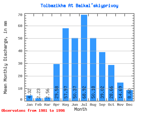
| Units: | m3/s |
| Statistic | Jan | Feb | Mar | Apr | May | Jun | Jul | Aug | Sep | Oct | Nov | Dec | Annual |
|---|---|---|---|---|---|---|---|---|---|---|---|---|---|
| Mean | 4.33 | 2.26 | 2.55 | 29.57 | 57.97 | 50.36 | 68.92 | 50.16 | 39.02 | 28.66 | 14.69 | 8.59 | 364.87 |
| Standard Deviation | 2.43 | 1.28 | 1.59 | 14.42 | 23.91 | 49.39 | 55.95 | 37.89 | 23.37 | 14.83 | 6.47 | 5.33 | 145.94 |
| Min | 1.76 | 0.00 | 0.33 | 8.93 | 25.29 | 16.13 | 12.20 | 13.39 | 6.62 | 5.95 | 5.47 | 4.17 | 178.55 |
| Max | 9.22 | 4.34 | 5.65 | 52.70 | 114.56 | 216.29 | 166.63 | 117.53 | 82.37 | 58.02 | 28.22 | 24.70 | 599.90 |
| Coefficient of Variation | 0.56 | 0.57 | 0.62 | 0.49 | 0.41 | 0.98 | 0.81 | 0.76 | 0.60 | 0.52 | 0.44 | 0.62 | 0.40 |
 Return to R-Arctic Net Home Page