|
|
|||||||||||||||||
| Point ID: 6069 | Downloads | Plots | Site Data | Code: 7180 |
|
|
|||||||||||||||||
| Download | |
|---|---|
| Site Descriptor Information | Site Time Series Data |
| Link to all available data | |
| View: | Time Series | All |
| Units: | mm |
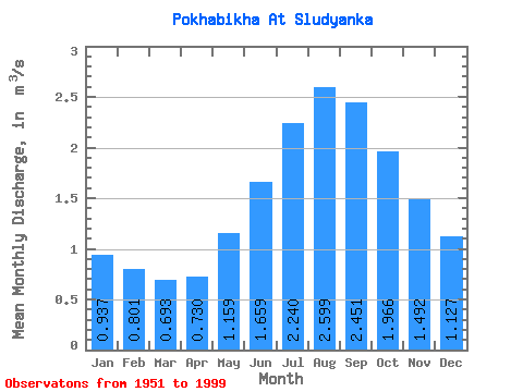
| Statistic | Jan | Feb | Mar | Apr | May | Jun | Jul | Aug | Sep | Oct | Nov | Dec | Annual |
|---|---|---|---|---|---|---|---|---|---|---|---|---|---|
| Mean | 0.94 | 0.80 | 0.69 | 0.73 | 1.16 | 1.66 | 2.24 | 2.60 | 2.45 | 1.97 | 1.49 | 1.13 | 1.49 |
| Standard Deviation | 0.27 | 0.25 | 0.17 | 0.17 | 0.27 | 0.42 | 0.92 | 0.95 | 0.80 | 0.56 | 0.39 | 0.28 | 0.34 |
| Min | 0.45 | 0.42 | 0.38 | 0.34 | 0.70 | 0.96 | 0.96 | 1.35 | 1.21 | 1.10 | 0.93 | 0.60 | 0.97 |
| Max | 1.77 | 1.84 | 1.16 | 1.19 | 2.28 | 2.92 | 4.74 | 5.35 | 5.14 | 4.18 | 2.91 | 2.02 | 2.47 |
| Coefficient of Variation | 0.29 | 0.31 | 0.25 | 0.23 | 0.24 | 0.26 | 0.41 | 0.37 | 0.33 | 0.28 | 0.26 | 0.25 | 0.23 |
 Return to R-Arctic Net Home Page