|
|
|||||||||||||||||
| Point ID: 6069 | Downloads | Plots | Site Data | Code: 7180 |
|
|
|||||||||||||||||
| Download | |
|---|---|
| Site Descriptor Information | Site Time Series Data |
| Link to all available data | |
| View: | Time Series | All |
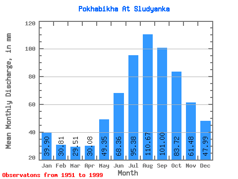
| Units: | m3/s |
| Statistic | Jan | Feb | Mar | Apr | May | Jun | Jul | Aug | Sep | Oct | Nov | Dec | Annual |
|---|---|---|---|---|---|---|---|---|---|---|---|---|---|
| Mean | 39.89 | 31.08 | 29.50 | 30.07 | 49.36 | 68.35 | 95.37 | 110.64 | 100.98 | 83.72 | 61.50 | 47.98 | 745.43 |
| Standard Deviation | 11.54 | 9.73 | 7.33 | 7.04 | 11.66 | 17.43 | 39.30 | 40.44 | 32.83 | 23.81 | 16.06 | 12.15 | 169.70 |
| Min | 19.16 | 16.29 | 16.18 | 14.01 | 29.80 | 39.56 | 40.87 | 57.48 | 49.86 | 46.83 | 38.32 | 25.55 | 488.37 |
| Max | 75.36 | 71.38 | 49.39 | 49.04 | 97.07 | 120.33 | 201.81 | 227.78 | 211.81 | 177.97 | 119.92 | 86.00 | 1240.16 |
| Coefficient of Variation | 0.29 | 0.31 | 0.25 | 0.23 | 0.24 | 0.26 | 0.41 | 0.37 | 0.33 | 0.28 | 0.26 | 0.25 | 0.23 |
 Return to R-Arctic Net Home Page