|
|
|||||||||||||||||
| Point ID: 6039 | Downloads | Plots | Site Data | Code: 7006 |
|
|
|||||||||||||||||
| Download | |
|---|---|
| Site Descriptor Information | Site Time Series Data |
| Link to all available data | |
| View: | Time Series | All |
| Units: | mm |
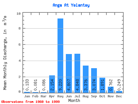
| Statistic | Jan | Feb | Mar | Apr | May | Jun | Jul | Aug | Sep | Oct | Nov | Dec | Annual |
|---|---|---|---|---|---|---|---|---|---|---|---|---|---|
| Mean | 0.13 | 0.08 | 0.09 | 2.15 | 9.22 | 4.81 | 4.85 | 3.38 | 3.07 | 1.89 | 0.76 | 0.25 | 2.64 |
| Standard Deviation | 0.25 | 0.16 | 0.20 | 1.60 | 4.31 | 3.49 | 4.02 | 1.97 | 2.11 | 0.92 | 0.49 | 0.36 | 0.76 |
| Min | 0.00 | 0.00 | 0.00 | 0.20 | 0.37 | 1.01 | 0.01 | 0.87 | 0.89 | 0.51 | 0.13 | 0.00 | 1.20 |
| Max | 0.93 | 0.64 | 1.07 | 7.56 | 19.80 | 22.10 | 16.90 | 7.85 | 9.90 | 3.96 | 2.16 | 1.46 | 4.37 |
| Coefficient of Variation | 1.88 | 2.01 | 2.38 | 0.74 | 0.47 | 0.72 | 0.83 | 0.58 | 0.69 | 0.49 | 0.64 | 1.46 | 0.29 |
 Return to R-Arctic Net Home Page