|
|
|||||||||||||||||
| Point ID: 6039 | Downloads | Plots | Site Data | Code: 7006 |
|
|
|||||||||||||||||
| Download | |
|---|---|
| Site Descriptor Information | Site Time Series Data |
| Link to all available data | |
| View: | Time Series | All |
| Units: | m3/s |
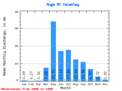
| Statistic | Jan | Feb | Mar | Apr | May | Jun | Jul | Aug | Sep | Oct | Nov | Dec | Annual |
|---|---|---|---|---|---|---|---|---|---|---|---|---|---|
| Mean | 0.49 | 0.27 | 0.32 | 7.68 | 33.96 | 17.14 | 17.86 | 12.44 | 10.96 | 6.97 | 2.72 | 0.92 | 114.42 |
| Standard Deviation | 0.92 | 0.54 | 0.75 | 5.70 | 15.86 | 12.43 | 14.82 | 7.26 | 7.52 | 3.39 | 1.74 | 1.34 | 32.98 |
| Min | 0.00 | 0.00 | 0.00 | 0.71 | 1.36 | 3.60 | 0.06 | 3.21 | 3.17 | 1.88 | 0.46 | 0.00 | 51.97 |
| Max | 3.43 | 2.15 | 3.94 | 26.95 | 72.94 | 78.79 | 62.25 | 28.92 | 35.30 | 14.59 | 7.70 | 5.38 | 189.67 |
| Coefficient of Variation | 1.88 | 2.01 | 2.38 | 0.74 | 0.47 | 0.72 | 0.83 | 0.58 | 0.69 | 0.49 | 0.64 | 1.46 | 0.29 |
 Return to R-Arctic Net Home Page