|
|
|||||||||||||||||
| Point ID: 600 | Downloads | Plots | Site Data | Code: 07AD002 |
|
|
|||||||||||||||||
| Download | |
|---|---|
| Site Descriptor Information | Site Time Series Data |
| Link to all available data | |
| View: | Time Series | All |
| Units: | mm |
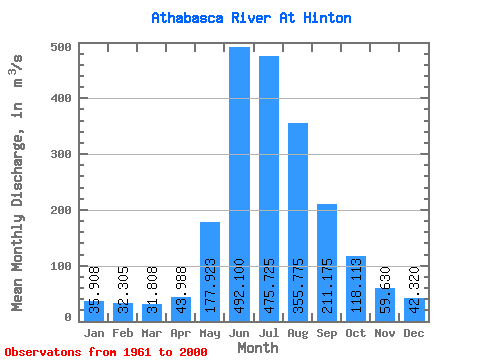
| Statistic | Jan | Feb | Mar | Apr | May | Jun | Jul | Aug | Sep | Oct | Nov | Dec | Annual |
|---|---|---|---|---|---|---|---|---|---|---|---|---|---|
| Mean | 35.91 | 32.30 | 31.81 | 43.99 | 177.92 | 492.10 | 475.73 | 355.77 | 211.18 | 118.11 | 59.63 | 42.32 | 173.02 |
| Standard Deviation | 8.16 | 5.38 | 5.76 | 8.21 | 60.08 | 99.04 | 90.38 | 62.44 | 44.41 | 30.68 | 12.81 | 11.87 | 21.34 |
| Min | 22.50 | 18.70 | 16.90 | 31.10 | 66.40 | 308.00 | 316.00 | 269.00 | 132.00 | 69.60 | 34.40 | 24.10 | 140.22 |
| Max | 68.30 | 46.60 | 41.90 | 60.60 | 310.00 | 752.00 | 672.00 | 544.00 | 359.00 | 231.00 | 98.60 | 100.00 | 228.39 |
| Coefficient of Variation | 0.23 | 0.17 | 0.18 | 0.19 | 0.34 | 0.20 | 0.19 | 0.17 | 0.21 | 0.26 | 0.21 | 0.28 | 0.12 |
 Return to R-Arctic Net Home Page