|
|
|||||||||||||||||
| Point ID: 600 | Downloads | Plots | Site Data | Code: 07AD002 |
|
|
|||||||||||||||||
| Download | |
|---|---|
| Site Descriptor Information | Site Time Series Data |
| Link to all available data | |
| View: | Time Series | All |
| Units: | m3/s |
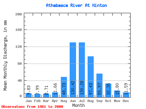
| Statistic | Jan | Feb | Mar | Apr | May | Jun | Jul | Aug | Sep | Oct | Nov | Dec | Annual |
|---|---|---|---|---|---|---|---|---|---|---|---|---|---|
| Mean | 9.83 | 8.06 | 8.71 | 11.66 | 48.72 | 130.42 | 130.26 | 97.42 | 55.97 | 32.34 | 15.80 | 11.59 | 558.34 |
| Standard Deviation | 2.23 | 1.34 | 1.58 | 2.18 | 16.45 | 26.25 | 24.75 | 17.10 | 11.77 | 8.40 | 3.40 | 3.25 | 68.85 |
| Min | 6.16 | 4.67 | 4.63 | 8.24 | 18.18 | 81.63 | 86.53 | 73.66 | 34.98 | 19.06 | 9.12 | 6.60 | 452.50 |
| Max | 18.70 | 11.63 | 11.47 | 16.06 | 84.89 | 199.30 | 184.01 | 148.96 | 95.15 | 63.25 | 26.13 | 27.38 | 737.02 |
| Coefficient of Variation | 0.23 | 0.17 | 0.18 | 0.19 | 0.34 | 0.20 | 0.19 | 0.17 | 0.21 | 0.26 | 0.21 | 0.28 | 0.12 |
 Return to R-Arctic Net Home Page