|
|
|||||||||||||||||
| Point ID: 598 | Downloads | Plots | Site Data | Code: 07AC008 |
|
|
|||||||||||||||||
| Download | |
|---|---|
| Site Descriptor Information | Site Time Series Data |
| Link to all available data | |
| View: | Time Series | All |
| Units: | mm |
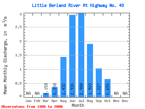
| Statistic | Jan | Feb | Mar | Apr | May | Jun | Jul | Aug | Sep | Oct | Nov | Dec | Annual |
|---|---|---|---|---|---|---|---|---|---|---|---|---|---|
| Mean | 0.16 | 0.36 | 1.43 | 2.93 | 2.99 | 1.90 | 1.03 | 0.66 | |||||
| Standard Deviation | 0.05 | 0.15 | 0.64 | 1.41 | 1.70 | 1.22 | 0.43 | 0.29 | |||||
| Min | 0.11 | 0.20 | 0.36 | 0.79 | 0.63 | 0.53 | 0.49 | 0.40 | |||||
| Max | 0.29 | 0.69 | 3.22 | 6.16 | 6.10 | 4.85 | 2.13 | 1.49 | |||||
| Coefficient of Variation | 0.29 | 0.43 | 0.44 | 0.48 | 0.57 | 0.64 | 0.42 | 0.45 |
 Return to R-Arctic Net Home Page