|
|
|||||||||||||||||
| Point ID: 598 | Downloads | Plots | Site Data | Code: 07AC008 |
|
|
|||||||||||||||||
| Download | |
|---|---|
| Site Descriptor Information | Site Time Series Data |
| Link to all available data | |
| View: | Time Series | All |
| Units: | m3/s |
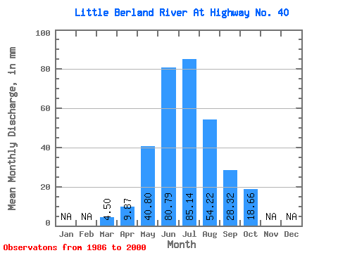
| Statistic | Jan | Feb | Mar | Apr | May | Jun | Jul | Aug | Sep | Oct | Nov | Dec | Annual |
|---|---|---|---|---|---|---|---|---|---|---|---|---|---|
| Mean | 4.51 | 9.88 | 40.80 | 80.79 | 85.13 | 54.21 | 28.31 | 18.65 | |||||
| Standard Deviation | 1.33 | 4.28 | 18.11 | 38.86 | 48.53 | 34.60 | 12.00 | 8.32 | |||||
| Min | 3.19 | 5.38 | 10.34 | 21.84 | 17.95 | 14.98 | 13.59 | 11.31 | |||||
| Max | 8.32 | 18.97 | 91.74 | 169.86 | 173.78 | 138.17 | 58.73 | 42.45 | |||||
| Coefficient of Variation | 0.29 | 0.43 | 0.44 | 0.48 | 0.57 | 0.64 | 0.42 | 0.45 |
 Return to R-Arctic Net Home Page