|
|
|||||||||||||||||
| Point ID: 5917 | Downloads | Plots | Site Data | Code: 1497 |
|
|
|||||||||||||||||
| Download | |
|---|---|
| Site Descriptor Information | Site Time Series Data |
| Link to all available data | |
| View: | Time Series | All |
| Units: | mm |
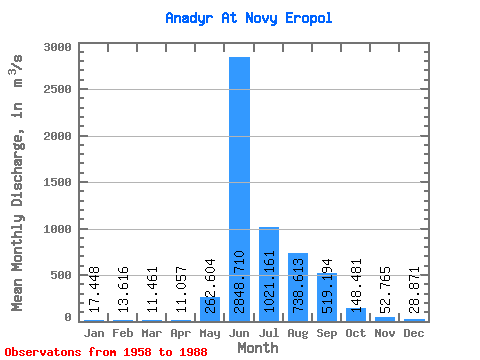
| Statistic | Jan | Feb | Mar | Apr | May | Jun | Jul | Aug | Sep | Oct | Nov | Dec | Annual |
|---|---|---|---|---|---|---|---|---|---|---|---|---|---|
| Mean | 17.45 | 13.62 | 11.46 | 11.06 | 262.60 | 2848.71 | 1021.16 | 738.61 | 519.19 | 148.48 | 52.77 | 28.87 | 472.83 |
| Standard Deviation | 4.54 | 4.49 | 4.00 | 4.52 | 500.54 | 765.14 | 468.23 | 241.80 | 307.28 | 85.75 | 22.68 | 11.03 | 107.53 |
| Min | 10.10 | 5.43 | 4.24 | 3.29 | 5.81 | 1440.00 | 385.00 | 314.00 | 180.00 | 64.10 | 25.30 | 12.00 | 306.30 |
| Max | 29.80 | 23.40 | 19.50 | 23.70 | 2090.00 | 4510.00 | 2200.00 | 1190.00 | 1290.00 | 449.00 | 131.00 | 58.70 | 756.69 |
| Coefficient of Variation | 0.26 | 0.33 | 0.35 | 0.41 | 1.91 | 0.27 | 0.46 | 0.33 | 0.59 | 0.58 | 0.43 | 0.38 | 0.23 |
 Return to R-Arctic Net Home Page