|
|
|||||||||||||||||
| Point ID: 5917 | Downloads | Plots | Site Data | Code: 1497 |
|
|
|||||||||||||||||
| Download | |
|---|---|
| Site Descriptor Information | Site Time Series Data |
| Link to all available data | |
| View: | Time Series | All |
| Units: | m3/s |
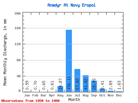
| Statistic | Jan | Feb | Mar | Apr | May | Jun | Jul | Aug | Sep | Oct | Nov | Dec | Annual |
|---|---|---|---|---|---|---|---|---|---|---|---|---|---|
| Mean | 0.99 | 0.70 | 0.65 | 0.61 | 14.87 | 156.11 | 57.81 | 41.82 | 28.45 | 8.41 | 2.89 | 1.64 | 315.49 |
| Standard Deviation | 0.26 | 0.23 | 0.23 | 0.25 | 28.34 | 41.93 | 26.51 | 13.69 | 16.84 | 4.86 | 1.24 | 0.62 | 71.75 |
| Min | 0.57 | 0.28 | 0.24 | 0.18 | 0.33 | 78.91 | 21.80 | 17.78 | 9.86 | 3.63 | 1.39 | 0.68 | 204.37 |
| Max | 1.69 | 1.21 | 1.10 | 1.30 | 118.33 | 247.14 | 124.56 | 67.38 | 70.69 | 25.42 | 7.18 | 3.32 | 504.88 |
| Coefficient of Variation | 0.26 | 0.33 | 0.35 | 0.41 | 1.91 | 0.27 | 0.46 | 0.33 | 0.59 | 0.58 | 0.43 | 0.38 | 0.23 |
 Return to R-Arctic Net Home Page