|
|
|||||||||||||||||
| Point ID: 5904 | Downloads | Plots | Site Data | Code: 1371 |
|
|
|||||||||||||||||
| Download | |
|---|---|
| Site Descriptor Information | Site Time Series Data |
| Link to all available data | |
| View: | Time Series | All |
| Units: | mm |
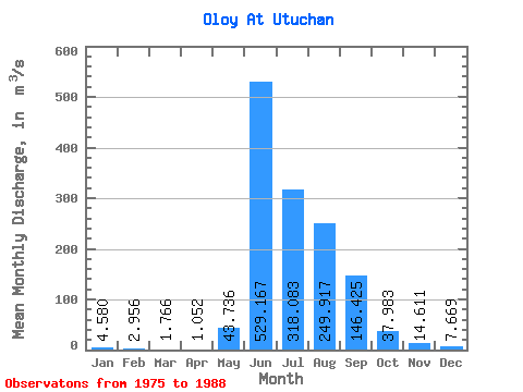
| Statistic | Jan | Feb | Mar | Apr | May | Jun | Jul | Aug | Sep | Oct | Nov | Dec | Annual |
|---|---|---|---|---|---|---|---|---|---|---|---|---|---|
| Mean | 4.58 | 2.96 | 1.77 | 1.05 | 43.74 | 529.17 | 318.08 | 249.92 | 146.43 | 37.98 | 14.61 | 7.67 | 113.16 |
| Standard Deviation | 3.76 | 3.58 | 1.86 | 0.39 | 25.92 | 126.90 | 113.13 | 70.31 | 71.37 | 13.88 | 5.89 | 4.16 | 20.64 |
| Min | 1.75 | 1.02 | 0.61 | 0.36 | 4.83 | 319.00 | 212.00 | 153.00 | 93.50 | 20.80 | 8.39 | 4.52 | 87.37 |
| Max | 16.00 | 14.20 | 7.49 | 1.75 | 87.30 | 727.00 | 608.00 | 358.00 | 317.00 | 72.80 | 26.00 | 17.90 | 159.49 |
| Coefficient of Variation | 0.82 | 1.21 | 1.05 | 0.37 | 0.59 | 0.24 | 0.36 | 0.28 | 0.49 | 0.37 | 0.40 | 0.54 | 0.18 |
 Return to R-Arctic Net Home Page