|
|
|||||||||||||||||
| Point ID: 5904 | Downloads | Plots | Site Data | Code: 1371 |
|
|
|||||||||||||||||
| Download | |
|---|---|
| Site Descriptor Information | Site Time Series Data |
| Link to all available data | |
| View: | Time Series | All |
| Units: | m3/s |
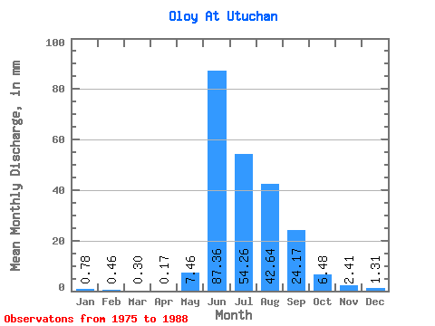
| Statistic | Jan | Feb | Mar | Apr | May | Jun | Jul | Aug | Sep | Oct | Nov | Dec | Annual |
|---|---|---|---|---|---|---|---|---|---|---|---|---|---|
| Mean | 0.78 | 0.46 | 0.30 | 0.17 | 7.46 | 87.36 | 54.26 | 42.63 | 24.17 | 6.48 | 2.41 | 1.31 | 227.48 |
| Standard Deviation | 0.64 | 0.56 | 0.32 | 0.06 | 4.42 | 20.95 | 19.30 | 11.99 | 11.78 | 2.37 | 0.97 | 0.71 | 41.48 |
| Min | 0.30 | 0.16 | 0.10 | 0.06 | 0.82 | 52.66 | 36.16 | 26.10 | 15.44 | 3.55 | 1.39 | 0.77 | 175.63 |
| Max | 2.73 | 2.21 | 1.28 | 0.29 | 14.89 | 120.02 | 103.71 | 61.06 | 52.34 | 12.42 | 4.29 | 3.05 | 320.61 |
| Coefficient of Variation | 0.82 | 1.21 | 1.05 | 0.37 | 0.59 | 0.24 | 0.36 | 0.28 | 0.49 | 0.37 | 0.40 | 0.54 | 0.18 |
 Return to R-Arctic Net Home Page