|
|
|||||||||||||||||
| Point ID: 5891 | Downloads | Plots | Site Data | Code: 1303 |
|
|
|||||||||||||||||
| Download | |
|---|---|
| Site Descriptor Information | Site Time Series Data |
| Link to all available data | |
| View: | Time Series | All |
| Units: | mm |
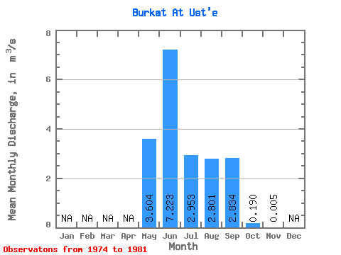
| Statistic | Jan | Feb | Mar | Apr | May | Jun | Jul | Aug | Sep | Oct | Nov | Dec | Annual |
|---|---|---|---|---|---|---|---|---|---|---|---|---|---|
| Mean | 3.60 | 7.22 | 2.95 | 2.80 | 2.83 | 0.19 | 0.01 | ||||||
| Standard Deviation | 1.86 | 4.36 | 1.67 | 1.54 | 2.09 | 0.12 | |||||||
| Min | 1.52 | 3.11 | 1.53 | 0.84 | 0.63 | 0.01 | 0.01 | ||||||
| Max | 6.01 | 16.00 | 6.34 | 5.52 | 6.76 | 0.34 | 0.01 | ||||||
| Coefficient of Variation | 0.52 | 0.60 | 0.56 | 0.55 | 0.74 | 0.64 |
 Return to R-Arctic Net Home Page