|
|
|||||||||||||||||
| Point ID: 5891 | Downloads | Plots | Site Data | Code: 1303 |
|
|
|||||||||||||||||
| Download | |
|---|---|
| Site Descriptor Information | Site Time Series Data |
| Link to all available data | |
| View: | Time Series | All |
| Units: | m3/s |
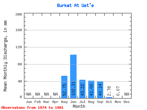
| Statistic | Jan | Feb | Mar | Apr | May | Jun | Jul | Aug | Sep | Oct | Nov | Dec | Annual |
|---|---|---|---|---|---|---|---|---|---|---|---|---|---|
| Mean | 52.74 | 102.30 | 43.21 | 41.00 | 40.15 | 2.79 | 0.07 | ||||||
| Standard Deviation | 27.22 | 61.79 | 24.38 | 22.50 | 29.62 | 1.79 | |||||||
| Min | 22.24 | 44.05 | 22.39 | 12.29 | 8.92 | 0.09 | 0.07 | ||||||
| Max | 87.95 | 226.62 | 92.78 | 80.78 | 95.75 | 4.98 | 0.07 | ||||||
| Coefficient of Variation | 0.52 | 0.60 | 0.56 | 0.55 | 0.74 | 0.64 |
 Return to R-Arctic Net Home Page