|
|
|||||||||||||||||
| Point ID: 587 | Downloads | Plots | Site Data | Code: 07AA008 |
|
|
|||||||||||||||||
| Download | |
|---|---|
| Site Descriptor Information | Site Time Series Data |
| Link to all available data | |
| View: | Time Series | All |
| Units: | mm |
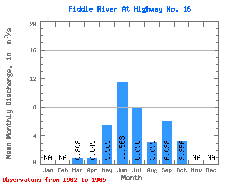
| Statistic | Jan | Feb | Mar | Apr | May | Jun | Jul | Aug | Sep | Oct | Nov | Dec | Annual |
|---|---|---|---|---|---|---|---|---|---|---|---|---|---|
| Mean | 0.81 | 0.84 | 5.56 | 11.56 | 8.10 | 3.10 | 6.04 | 3.36 | |||||
| Standard Deviation | 0.29 | 0.56 | 2.32 | 3.61 | 2.81 | 0.67 | 3.63 | 2.70 | |||||
| Min | 0.60 | 0.45 | 3.20 | 8.01 | 6.47 | 2.62 | 2.05 | 0.90 | |||||
| Max | 1.01 | 1.24 | 8.70 | 16.00 | 12.30 | 4.08 | 9.60 | 6.91 | |||||
| Coefficient of Variation | 0.35 | 0.66 | 0.42 | 0.31 | 0.35 | 0.21 | 0.60 | 0.81 |
 Return to R-Arctic Net Home Page