|
|
|||||||||||||||||
| Point ID: 587 | Downloads | Plots | Site Data | Code: 07AA008 |
|
|
|||||||||||||||||
| Download | |
|---|---|
| Site Descriptor Information | Site Time Series Data |
| Link to all available data | |
| View: | Time Series | All |
| Units: | m3/s |
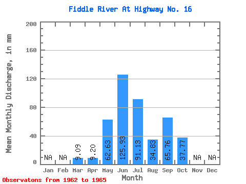
| Statistic | Jan | Feb | Mar | Apr | May | Jun | Jul | Aug | Sep | Oct | Nov | Dec | Annual |
|---|---|---|---|---|---|---|---|---|---|---|---|---|---|
| Mean | 9.09 | 9.20 | 62.62 | 125.92 | 91.11 | 34.83 | 65.75 | 37.76 | |||||
| Standard Deviation | 3.22 | 6.08 | 26.15 | 39.29 | 31.61 | 7.50 | 39.49 | 30.38 | |||||
| Min | 6.81 | 4.90 | 36.01 | 87.23 | 72.80 | 29.48 | 22.33 | 10.17 | |||||
| Max | 11.37 | 13.51 | 97.89 | 174.25 | 138.40 | 45.91 | 104.55 | 77.75 | |||||
| Coefficient of Variation | 0.35 | 0.66 | 0.42 | 0.31 | 0.35 | 0.21 | 0.60 | 0.81 |
 Return to R-Arctic Net Home Page