|
|
|||||||||||||||||
| Point ID: 5866 | Downloads | Plots | Site Data | Code: 1099 |
|
|
|||||||||||||||||
| Download | |
|---|---|
| Site Descriptor Information | Site Time Series Data |
| Link to all available data | |
| View: | Time Series | All |
| Units: | mm |
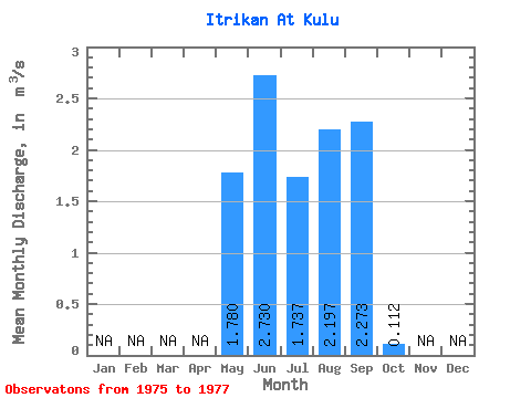
| Statistic | Jan | Feb | Mar | Apr | May | Jun | Jul | Aug | Sep | Oct | Nov | Dec | Annual |
|---|---|---|---|---|---|---|---|---|---|---|---|---|---|
| Mean | 1.78 | 2.73 | 1.74 | 2.20 | 2.27 | 0.11 | |||||||
| Standard Deviation | 1.28 | 1.50 | 1.27 | 1.46 | 1.99 | 0.08 | |||||||
| Min | 0.76 | 1.22 | 0.98 | 0.63 | 0.23 | 0.03 | |||||||
| Max | 3.22 | 4.21 | 3.20 | 3.52 | 4.21 | 0.17 | |||||||
| Coefficient of Variation | 0.72 | 0.55 | 0.73 | 0.67 | 0.88 | 0.69 |
 Return to R-Arctic Net Home Page