|
|
|||||||||||||||||
| Point ID: 5866 | Downloads | Plots | Site Data | Code: 1099 |
|
|
|||||||||||||||||
| Download | |
|---|---|
| Site Descriptor Information | Site Time Series Data |
| Link to all available data | |
| View: | Time Series | All |
| Units: | m3/s |
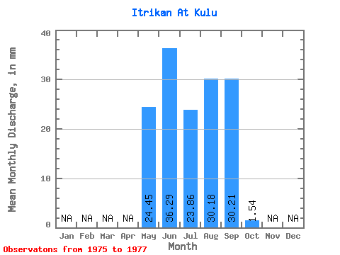
| Statistic | Jan | Feb | Mar | Apr | May | Jun | Jul | Aug | Sep | Oct | Nov | Dec | Annual |
|---|---|---|---|---|---|---|---|---|---|---|---|---|---|
| Mean | 24.45 | 36.29 | 23.85 | 30.17 | 30.22 | 1.53 | |||||||
| Standard Deviation | 17.61 | 19.88 | 17.41 | 20.05 | 26.48 | 1.05 | |||||||
| Min | 10.44 | 16.22 | 13.46 | 8.65 | 3.06 | 0.34 | |||||||
| Max | 44.22 | 55.96 | 43.95 | 48.34 | 55.96 | 2.33 | |||||||
| Coefficient of Variation | 0.72 | 0.55 | 0.73 | 0.67 | 0.88 | 0.69 |
 Return to R-Arctic Net Home Page