|
|
|||||||||||||||||
| Point ID: 5855 | Downloads | Plots | Site Data | Code: 1001 |
|
|
|||||||||||||||||
| Download | |
|---|---|
| Site Descriptor Information | Site Time Series Data |
| Link to all available data | |
| View: | Time Series | All |
| Units: | mm |
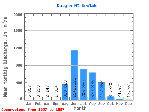
| Statistic | Jan | Feb | Mar | Apr | May | Jun | Jul | Aug | Sep | Oct | Nov | Dec | Annual |
|---|---|---|---|---|---|---|---|---|---|---|---|---|---|
| Mean | 5.82 | 3.30 | 2.15 | 1.96 | 360.82 | 1146.53 | 706.35 | 630.83 | 417.39 | 81.72 | 24.97 | 12.26 | 282.84 |
| Standard Deviation | 2.78 | 1.61 | 1.03 | 1.10 | 279.88 | 538.72 | 254.78 | 273.57 | 237.66 | 33.79 | 9.45 | 6.13 | 74.78 |
| Min | 1.71 | 0.89 | 0.54 | 0.43 | 47.80 | 162.00 | 228.00 | 173.00 | 95.70 | 25.50 | 8.53 | 3.35 | 145.41 |
| Max | 15.30 | 7.67 | 5.34 | 6.07 | 1160.00 | 2570.00 | 1430.00 | 1330.00 | 1100.00 | 221.00 | 53.10 | 34.30 | 425.75 |
| Coefficient of Variation | 0.48 | 0.49 | 0.48 | 0.56 | 0.78 | 0.47 | 0.36 | 0.43 | 0.57 | 0.41 | 0.38 | 0.50 | 0.26 |
 Return to R-Arctic Net Home Page