|
|
|||||||||||||||||
| Point ID: 5855 | Downloads | Plots | Site Data | Code: 1001 |
|
|
|||||||||||||||||
| Download | |
|---|---|
| Site Descriptor Information | Site Time Series Data |
| Link to all available data | |
| View: | Time Series | All |
| Units: | m3/s |
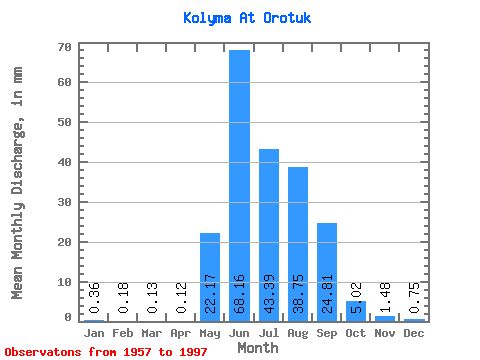
| Statistic | Jan | Feb | Mar | Apr | May | Jun | Jul | Aug | Sep | Oct | Nov | Dec | Annual |
|---|---|---|---|---|---|---|---|---|---|---|---|---|---|
| Mean | 0.36 | 0.18 | 0.13 | 0.12 | 22.16 | 68.16 | 43.38 | 38.75 | 24.81 | 5.02 | 1.48 | 0.75 | 204.73 |
| Standard Deviation | 0.17 | 0.09 | 0.06 | 0.07 | 17.19 | 32.03 | 15.65 | 16.80 | 14.13 | 2.08 | 0.56 | 0.38 | 54.13 |
| Min | 0.10 | 0.05 | 0.03 | 0.03 | 2.94 | 9.63 | 14.00 | 10.63 | 5.69 | 1.57 | 0.51 | 0.21 | 105.25 |
| Max | 0.94 | 0.43 | 0.33 | 0.36 | 71.25 | 152.78 | 87.83 | 81.69 | 65.39 | 13.57 | 3.16 | 2.11 | 308.18 |
| Coefficient of Variation | 0.48 | 0.49 | 0.48 | 0.56 | 0.78 | 0.47 | 0.36 | 0.43 | 0.57 | 0.41 | 0.38 | 0.50 | 0.26 |
 Return to R-Arctic Net Home Page