|
|
|||||||||||||||||
| Point ID: 5854 | Downloads | Plots | Site Data | Code: 10MD002 |
|
|
|||||||||||||||||
| Download | |
|---|---|
| Site Descriptor Information | Site Time Series Data |
| Link to all available data | |
| View: | Time Series | All |
| Units: | mm |
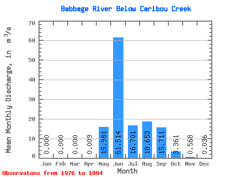
| Statistic | Jan | Feb | Mar | Apr | May | Jun | Jul | Aug | Sep | Oct | Nov | Dec | Annual |
|---|---|---|---|---|---|---|---|---|---|---|---|---|---|
| Mean | 0.00 | 0.00 | 0.00 | 0.01 | 15.98 | 61.51 | 16.70 | 18.65 | 15.71 | 3.36 | 0.57 | 0.04 | 11.33 |
| Standard Deviation | 0.00 | 0.00 | 0.00 | 0.03 | 16.07 | 24.36 | 7.53 | 13.90 | 10.02 | 2.18 | 0.62 | 0.10 | 3.76 |
| Min | 0.00 | 0.00 | 0.00 | 0.00 | 0.12 | 22.40 | 2.16 | 3.77 | 4.25 | 0.72 | 0.00 | 0.00 | 3.64 |
| Max | 0.00 | 0.00 | 0.00 | 0.13 | 49.10 | 94.50 | 29.30 | 53.40 | 33.10 | 9.42 | 2.36 | 0.43 | 18.99 |
| Coefficient of Variation | 3.51 | 1.00 | 0.40 | 0.45 | 0.74 | 0.64 | 0.65 | 1.10 | 2.90 | 0.33 |
 Return to R-Arctic Net Home Page