|
|
|||||||||||||||||
| Point ID: 5854 | Downloads | Plots | Site Data | Code: 10MD002 |
|
|
|||||||||||||||||
| Download | |
|---|---|
| Site Descriptor Information | Site Time Series Data |
| Link to all available data | |
| View: | Time Series | All |
| Units: | m3/s |
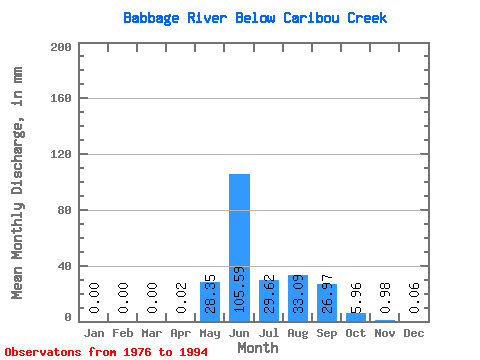
| Statistic | Jan | Feb | Mar | Apr | May | Jun | Jul | Aug | Sep | Oct | Nov | Dec | Annual |
|---|---|---|---|---|---|---|---|---|---|---|---|---|---|
| Mean | 0.00 | 0.00 | 0.00 | 0.02 | 28.34 | 105.59 | 29.62 | 33.08 | 26.97 | 5.96 | 0.98 | 0.06 | 236.76 |
| Standard Deviation | 0.00 | 0.00 | 0.00 | 0.06 | 28.50 | 41.82 | 13.36 | 24.64 | 17.19 | 3.87 | 1.07 | 0.19 | 78.51 |
| Min | 0.00 | 0.00 | 0.00 | 0.00 | 0.21 | 38.45 | 3.83 | 6.69 | 7.29 | 1.28 | 0.00 | 0.00 | 76.03 |
| Max | 0.00 | 0.00 | 0.00 | 0.23 | 87.08 | 162.22 | 51.96 | 94.70 | 56.82 | 16.71 | 4.05 | 0.77 | 396.88 |
| Coefficient of Variation | 3.51 | 1.00 | 0.40 | 0.45 | 0.74 | 0.64 | 0.65 | 1.10 | 2.90 | 0.33 |
 Return to R-Arctic Net Home Page